Our local beaches on old maps and charts
As many of you are aware, and in tandem with the seaweed prints side of Coast & Wild, I have a bit of a passion for old maps & nautical charts of our local coastline.
For the past few years, I've been slowly building up a collection of maps from different periods - mainly to research old place names that are now sadly being lost to time.
So this blog post is all about the beaches we frequent, and the maps that I (Jon) have collated.
I think it simplest if I start with the oldest and then run through to the newest (albeit nearly 150 years old).
Around 1748, a Lewis Morris set about to create a series of nautical charts of St George’s Channel, charting the local harbours, sea depths, wreck sites and tidal flows - this he did, starting in north Wales and working his way down the coast to finally end at Milford Haven. En route he charted Newport Bay and Dinas Island (shown below), and as with most nautical charts, the first thing you'll notice is that it does not point north - instead charting the harbour as if you were at sea and approaching the bay dead centre.
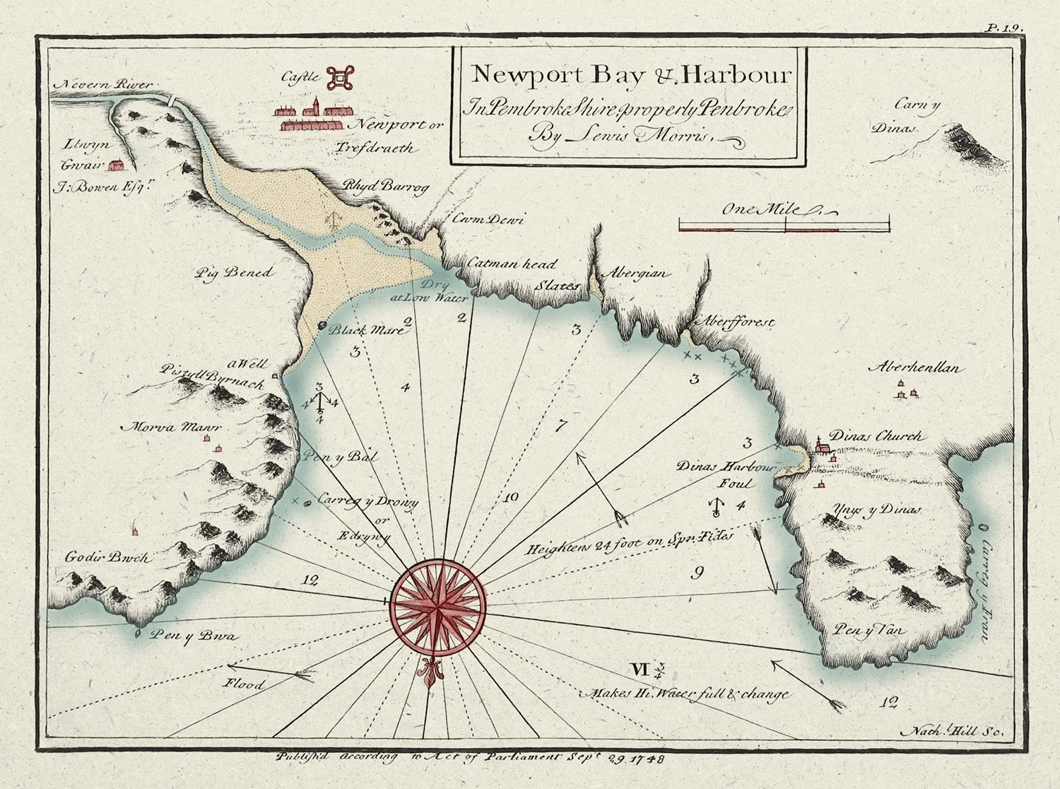
The 1748 Lewis Morris nautical chart of Newport Bay.
You might notice on this chart a few upside down anchors - these denote safe areas to drop anchor in the bay, the X's on the other hand mark points where known wrecks are located. Arrows show the general tidal direction, and the numbers indicate depth in fathoms.
Another interesting point to note on this chart is Dinas Harbour with an intact Church, this chart predates the great storm that wiped out a large section of the now named hamlet of Cwm-yr-Eglwys. Many maps pre-dating this event, bear the name Dinas where Cwm-yr-Eglwys is now shown on post event dated maps.
Cwm is a favourite of ours, and not just for seaweed foraging, in the summer on a sunny day - you could quite well believe you were in the Caribbean or the Med.
This next chart is from 1775 and is a more general view of our part of the coast. Note again 'Dinas' being marked where Cwm-yr-Eglwys now is. This chart also works on two levels, not only does it allow you to navigate the coastline with an idea of sea depth and coastline shape - if you turn it upside down, then the shaded in mountains start to make sense, as the general outline of the peaks is now how you'd see them if you were at sea.

1775 nautical chart of Fishguard and Newport Bays.
The next two maps were drawn in 1814 and are Ordnance Survey two inches to the mile in scale. As far as I've been able to tell, the maps never made it to publication.
Again note 'Dinas' where Cwm-yr-Eglwys is now marked on modern maps. These early OS maps are great for referencing the lack of built-up areas in north Pembrokeshire - for example, the first map below shows no buildings at all where most people now consider Dinas Cross to be, there is also no Sailor’s Safety at Pwllgwaelod either. They are also the first of the maps to show smaller coves and inlets with an actual name.

Ordnance Survey map of Fishguard Bay from 1814.
On these, Aber Ascud (now called Aber Bach) and Pwllgwaelod make an appearance - sadly, Aberforrest and Aber Rhigian are still absent.

Ordnance Survey map of Newport Bay from 1814.
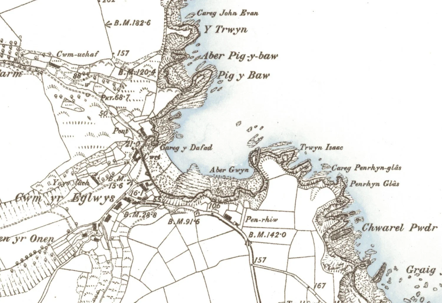
Next up are the OS six-inches to the mile maps, of which I've cropped sections from. We now have two names at Aber Bach - Aber Bach and Aber Hescwm, with Aber Ascud now missing.

Crop of an 1888 Aber Bach / Aber Hesgwm map.
The name Pwllgwaelod remains unchanged and the Sailor’s Safety is present, Cwm-yr-Eglwys is now shown where Dinas once was, and finally Aberforrest and Aber Rhigian make an appearance.
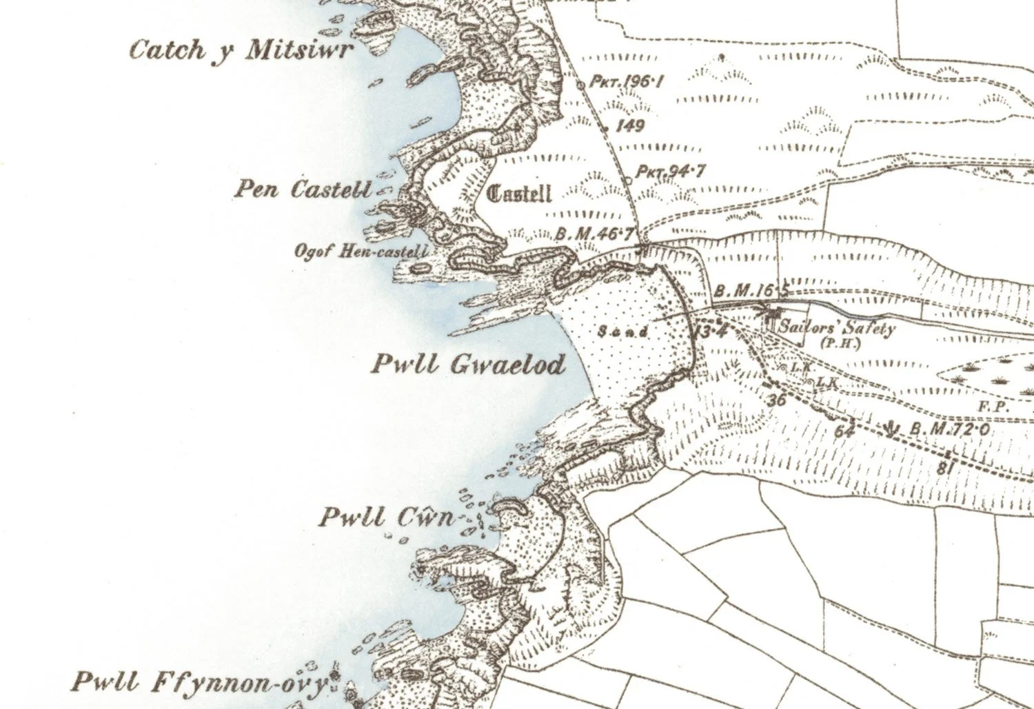
Crop from an 1888 map of Pwllgwaelod.
Crop from an 1888 map of Cwm yr Eglwys.

Crop from an 1888 map of Aberfforest and Aber Rhigian.
These are just sections from the maps I sell from our studio / gallery space and are a treasure trove of old names. You'll see that practically every rock, inlet, promontory, and hill now have names - this is especially so for the maps covering north Pembrokeshire. The same range of maps for further afield become more sparse in the naming of local features - maybe the surveyors loved the area so much that they didn't want to leave, and thus elongated their time here by hoovering up as many local names for any feature that they could find.